
Storm Ciara is bringing strong winds and heavy rain to Shropshire today, with gusts of 60 to 70mph likely.
A yellow warning for wind across Shropshire is active from 00:00 to 23:59, with an amber warning for wind covering the period 08:00 to 21:00.
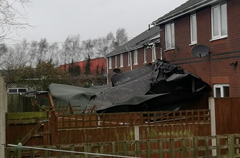
In Shrewsbury, felt roofing came off a building on Centurion Park in Kendal Road and struck several nearby houses causing damage to solar panels and the roof of one property.
A number of locations in Shropshire have already reported power outages including properties in the Bridgnorth, Cross Houses, Waters Upton and Market Drayton areas.
Powerlines and trees are reported to also be down across the county, flooding is also taking place on roads and land.
Train services between Shrewsbury and Birmingham were disrupted after a tree fell on the line at Cosford. The tree has since been removed and the line reopened.
Attingham Park near Shrewsbury is closed to visitors today. The National Trust run property is hoping to reopen tomorrow morning once the park has been checked.
Shrewsbury’s Quarry Swimming & Fitness Centre is also closed due to parts of the roof becoming loose. Priory Road has also been cordoned off for public safety as there is a risk they could fall from the roof onto the road.
Flood Alerts
The first phase of flood defences have been deployed in Frankwell, Shrewsbury.
A number of flood alerts are also in place across Shropshire:
– Ledwyche Brook and River Rea
– Lower Teme
– Rea Brook and Cound Brook
– River Lugg North of Leominster
– River Severn in Shropshire
– River Worfe
– Severn Vyrnwy confluence
– Tern and Perry Catchments
– Upper Teme
Drivers urged to take extra care in high winds
Drivers are being urged to take care on the roads with road users, particularly drivers of high-sided HGVs, caravans and motorcycles, advised to check the weather and driving conditions before setting out on journeys.
Highways England’s Head of Road Safety, Richard Leonard, said:
“We’re encouraging drivers to check the latest weather and travel conditions before setting off on journeys and consider if their journey is necessary and can be delayed until conditions improve. If you do intend to travel, then plan your journey and take extra care, allowing more time for your journey.
“In high winds, there’s a particular risk to lorries, caravans and motorbikes so we’d advise drivers of these vehicles to slow down.
“Drivers of other vehicles should be aware of sudden gusts of wind which can affect handling and braking, and give high-sided vehicles, caravans, and motorbikes plenty of space. In the event of persistent high winds we may need to close bridges to traffic for a period, so please be alert for warnings of closures and follow signed diversion routes.”
Train Travel
Train passengers are being urged to check travel details ahead of setting out for a journey.
Network Rail have imposed a 50mph speed restriction across all networks. A reduced service will be in place across many routes and some stations may not be served.
Transport for Wales Operations Director Martyn Brennan and Amanda Newton, Senior Incident Officer at Network Rail said: “Transport for Wales and Network Rail wish to urge all customers to check their journeys prior to travel.
“We’re expecting very stormy conditions and winds that have the potential to uproot trees and damage infrastructure.
“The safety of our customers and colleagues is our absolute priority and as such there are likely to be a number of speed restrictions in place around our network, while some other lines may be forced to close entirely. We are working closely together to minimise any disruption and will do all we can to keep our customers moving and informed.”
Weather Forecast
Today: Through the morning a band of heavy rain will move through the region accompanied by gales or severe gales. Rain will clear to heavy, squally showers in the afternoon with the odd sunny spell. A high of 13C.
Tonight: A largely cloudy night with showers, these possibly heavy and wintry over the higher ground, with some drier and clear spells inbetween. Winds will remain strong with gales. A low of 0C.
Monday: Dry through the morning with sunny spells and showers. Cloudier in the afternoon with rain which will be heavy, possibly with snow in places. Rain clearing to further showers later. A high of 6C.
Outlook for Tuesday to Thursday: Very windy on Tuesday with showers, wintry in places. Showers and bright spells on Wednesday, winds easing later. Wind and rain clearing to sunny spells and showers on Thursday.


 Shropshire Live is regulated by