

The River Severn has peaked in Ironbridge overnight at 6.6m with water levels remaining below the top of flood defences along The Wharfage.
On Monday the Environment Agency issued a Severe Flood Warning for Ironbridge, with river levels threatening to over-top flood barriers along The Wharfage. Residents were urged to evacuate their homes and were supported by Telford & Wrekin Council.
Leader of Telford & Wrekin Council, Councillor Shaun Davies said:
“We are working around the clock with our partners, the Environment Agency and the emergency services to support residents and businesses affected by the flooding.
“The river gauge at the Wharfage was measuring 6.62m as of 6.30am this morning and the flood waters are high but now slowly retreating.
“This is one of the closest calls we’ve seen with water coming within a few centimetres of topping over the barriers in Ironbridge. Roads and homes have been flooded on both sides of the river too. We are urging people to stay away from the area today.
“My heart goes out to everyone who has been affected as this will be the third time in less than two years that some people have suffered flood damage.
“We’ve been lucky at the Wharfage this time but we don’t want to be praying for a fourth time lucky if, or more likely when, this situation is repeated. Let’s not forget either that the barriers do not currently protect all at risk properties along the river, and many have no defences at all.
“We now need government to provide further grants for properties affected, and a better plan for the River Severn here in Ironbridge and as a whole. It looks like flooding is becoming the new normal so we need to be more protected.
“As a council, we are on our residents’ side and we will make sure that we are with them every step of the way as the situation develops.”
Flooding impact
Flooding has also impacted roads and homes in Coalbrookdale, Jackfield and Dale End, where a mixture of sandbags, pumps and temporary concrete walls are being used to reduce the impact of the floodwater.
In Shrewsbury, the River Severn peaked on Tuesday morning with 5.15m recorded at the Welsh Bridge. Levels are beginning to recede in the town with The Darwin shopping centre reopening today.
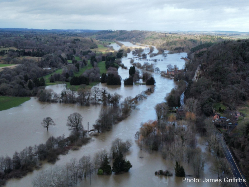
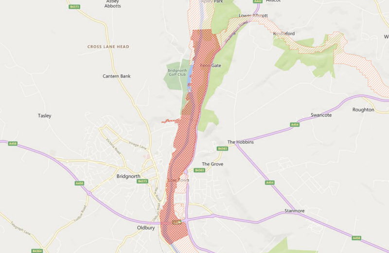
At 8.30am the River Severn was peaking in Bridgnorth.
Shropshire Council opened a flood reception centre at Castle Hall in West Castle Street at 9am. Council staff are on hand with advice and support.
A flood warning was issued for the River Vyrnwy at Maesbrook, Melverley and Llanymynech. River levels peaked on Monday at Crew Green but remain high. Llanymynech peaked at 5.3m on Sunday; Crew green at 6.63m on Monday.
Flooding has affected properties and roads in and around Melverley and Maesbrook, including Melverley to Melverley Green and Ponthen to Melverley roads.
Shropshire Council’s leader Lezley Picton has visited the Melverley area to meet local residents.
Levels on the River Severn across the county are expected to remain high in the coming days. Further rain is forecast for the weekend. The Environment Agency says its staff are closely monitoring the situation.
Shropshire Flooding Situation
The Environment Agency has issued a number of warnings and alerts for Shropshire.
Severe Flood Warning
Danger to life:
– River Severn at the Wharfage, Ironbridge
Flood Warnings
Flooding is expected:
– River Vyrnwy at Maesbrook
– River Vyrnwy at Melverley
– River Severn at Shrawardine, Montford Bridge and Mytton
– River Severn at Shrewsbury
– River Severn at the Showground and The Quarry, Shrewsbury
– River Severn at Buildwas
– River Severn at Ironbridge and Jackfield
– River Severn at Sutton Wharf
– River Severn at Bridgnorth
– River Severn at Quatford
– River Severn at Fort Pendlestone and Severn Hall
– River Severn at Hampton Loade and Highley
– River Severn at Pentre
– River Teme at Leintwardine and Walford
Flood Alerts
Flooding is possible:
– Severn Vyrnwy confluence
– River Severn in Shropshire
– Lower Teme
– Rea Brook and Cound Brook
– River Dee catchment in England from Whitchurch to Chester
– River Worfe
– Tern and Perry catchments
– Upper Teme
For the latest flood alerts and warnings see
https://check-for-flooding.service.gov.uk/alerts-and-warnings?q=Shropshire#alerts
Footpath closures
Shrewsbury
– Greyfriars Bridge to The Weir
– The Pig trough to West Midland Showground
– New Street to The Stew/Frankwell Riverside Car Park
Road Closures
Updated at 20:00 – 23/02/2022
Shrewsbury
– Roushill
– Sydney Avenue
– Gravel Hill Lane
– Atcham to Cross Houses and Chiltern Farm Lane
– Coleham Head Lane Closure into Town Centre
– Victoria Avenue
– Williams Way
Ironbridge
– The Wharfage, Ironbridge
– The Lloyds, Ironbridge
– Jackfield Road
– Ferry Road, Jackfield
Bridgnorth
– A442, Telford to Bridgnorth (Upstream of Bridgnorth and Fort Pendlestone)
– Southwell Riverside
– Severnside South Road and The Boat Yard
– Doctors Lane
– Severn Terrace
– Quayside
– Riverside and Friars Street
Other Areas
– Cressage to Eaton Constantine
– Long Lane, Craven Arms
– Bridge Street, Clun
– Church Street, Clun
Car Parks Closed
Shrewsbury
– Abbey Foregate
– Frankwell Main
– Frankwell Riverside
– St Julians Friars
– The Gap
– Ravens Meadows multi-storey closed due to power outage
Ironbridge
– Dale End
– The Wharfage
Bridgnorth
– Riverside car park
– Riverside West elevated car park
Any displaced resident permit holders holding a valid permit may park on Innage Lane Car Park or Severn Street Car Park during the road closures.
Bus Services
Shrewsbury
Shrewsbury bus station is currently closed due to flood risk, temporary bus terminus points are located at:
– New Park Road nr Beacalls Lane
– Abbey Foregate Car Park
– Outside Theatre Severn in Frankwell
The Park & Ride service is the best option for heading into Shrewsbury town centre.
Ironbridge
Services 8 & 18 are serving Madeley as normal, then diverting via the Ironbridge bypass direct to Much Wenlock, not serving the Gorge as the Lloyds is flooded and the section from the bottom of Madeley Bank is closed as well. No service to Jackfield either.
Service 19 is currently diverting after Lightmoor via the Lawley bypass and M54/A5 due to B4380 flooded at Atcham.
Bridgnorth
The A442 between Sutton Maddock island and Bandon Arms island is closed due to flooding and this is affecting bus service 113. Arriva is diverting the service through Rudge Heath past Worfield then on into Bridgnorth.
Train Services
A landslip between Shrewsbury and Hereford is causing disruption to services with no trains running between Shrewsbury and Hereford. Heavy rain caused the large landslip at Marshbrook, near Craven Arms.
Due to previous flooding at Welshpool, road transport is currently operating between Shrewsbury and Newtown.
Transport for Wales and West Midlands Railway are urging passengers to check before travelling.


 Shropshire Live is regulated by